MammothMap - Mammoth High Country Trail Map 1.0
Paid Version
Publisher Description
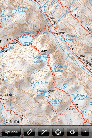
MammothMap brings the Mammoth High Country Trail Map by Tom Harrison Maps to the iPhone and iPod Touch. MammothMap covers the southern shore of Mono Lake, parts of the John Muir Wilderness and Ansel Adams Wilderness (including the Minarets), Mammoth Mountain, June Lake, Lake Mary, Lee Vining, the Mono Basin National Scenic Area, the eastern portion of Yosemite National Park, parts of Inyo National Forest and Sierra National Forest, and Devil's Postpile National Monument. The map shows trails, backcountry roads, highways, towns, water features, peaks, canyons, campgrounds, ranger stations, and more. This map is perfect for day hikes, backpacking, fishing, mountain biking, 4x4 backcountry touring, orienteering, geocaching, and just about any other way you'd want to explore this area. Navigate the map using standard touch gestures to zoom and drag. Mark your location, measure distances, orient yourself by taking bearings to landmarks, and use your iPhone's GPS to find your location on the map. Add your own markers to the map, and export them via email for display in Google Earth or other applications. Map data is included in the application, so you don't need an internet connection to use it.
Requires iOS 2.2.1 or later. Compatible with iPhone, iPad, and iPod touch.
About MammothMap - Mammoth High Country Trail Map
MammothMap - Mammoth High Country Trail Map is a paid app for iOS published in the Recreation list of apps, part of Home & Hobby.
The company that develops MammothMap - Mammoth High Country Trail Map is Patrick Leger. The latest version released by its developer is 1.0.
To install MammothMap - Mammoth High Country Trail Map on your iOS device, just click the green Continue To App button above to start the installation process. The app is listed on our website since 2009-03-07 and was downloaded 3 times. We have already checked if the download link is safe, however for your own protection we recommend that you scan the downloaded app with your antivirus. Your antivirus may detect the MammothMap - Mammoth High Country Trail Map as malware if the download link is broken.
How to install MammothMap - Mammoth High Country Trail Map on your iOS device:
- Click on the Continue To App button on our website. This will redirect you to the App Store.
- Once the MammothMap - Mammoth High Country Trail Map is shown in the iTunes listing of your iOS device, you can start its download and installation. Tap on the GET button to the right of the app to start downloading it.
- If you are not logged-in the iOS appstore app, you'll be prompted for your your Apple ID and/or password.
- After MammothMap - Mammoth High Country Trail Map is downloaded, you'll see an INSTALL button to the right. Tap on it to start the actual installation of the iOS app.
- Once installation is finished you can tap on the OPEN button to start it. Its icon will also be added to your device home screen.
